Scientists of the Faculty of Geology and Geography of Tomsk State University (TSU) were the first in the world to create a geological map of the Phoebe Region on Venus with a detailed description of volcanoes and magmatic centers. Based on the 1:500,000 mapping of the area, TSU geologists marked the potential landing sites for future spacecraft missions to Venus. The space industry will now get the most accurate data on the structural features of the planet’s surface for further research. The results of the study were published in the Planetary and Space Science (Q2).
The first detailed geological map of the Phoebe region was designed with the involvement of a group of scientists, including among others Ekaterina Antropova, a researcher at the Laboratory of Geochronology and Geodynamics of the TSU Faculty of Geology and Geography, Richard Ernst, a professor at the TSU Department of Petrography and Carleton University, Carlos Braga, a graduate of the TSU Faculty of Geology and Geography, Hafida El Bilali, a senior researcher at the TSU Laboratory of Geochronology and Geodynamics, Ken Buchan, a former employee of the Geological Survey of Canada, Jim Head (USA), a well-known planetologist and leading researcher from Brown University, and Arina Shimolina, a research engineer at the Laboratory of Geochronology and Geodynamics of the TSU Faculty of Geology and Geography. They are all members of the international team of scientists from Canada, Morocco, Russia, India and other countries that studies the geography, climate, volcanic processes and mapping of Venus.
TSU scientists conducted a geological mapping of the volcanic-magmatic structures of the Phoebe region, part of the Beta Atlas-Themis triangle (BAF) on Venus, which is characterized by a high density of volcanic structures and magmatic centers. It is one of the most useful and promising for space exploration.
The scientists were the first in the world to create a detailed geological map of this area with a detailed description of morphostructures. Previously, most of Venus was mapped on a smaller exploration scale – 1:10,000,000 and 1:5,000,000.
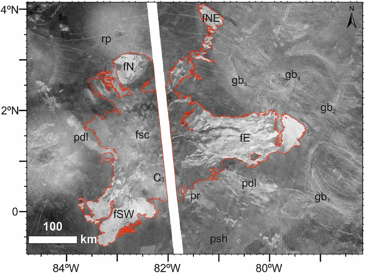
Thus, maps on a 1:500,000 scale with a total length of about 1,200 km will make it possible to more accurately characterize the geological structures on the surface of Venus and find favorable places for landing and sampling soil as part of potential space missions to Venus. For example, one of these is sending the Russian Venera-D orbiter and the lander to study the composition of the material of the planet’s surface structures.
In a new article, TSU staff explain in detail the structure and history of the geological development of a large volcanic and magmatic center located in the northwestern part of the Phoebe region on Venus. According to the author of the article, Ekaterina Antropova, a young scientist at the Faculty of Geology and Geography, Venus and Earth are quite similar, but the mechanisms of internal heat loss differ substantially.

– Unlike Earth, there is currently no plate-tectonic regime on Venus, and all volcanic-magmatic activities are characterized by intraplate conditions, explains Ekaterina Antropova. – Mantle diapirs play a key role in the transformation of the Venus’s surface. They are formed in the deep layers of the mantle and foster the development of a wide range of geological structures – shield volcanoes, corona, and others – at different stages of geological history. Mapping and detailed analysis of these structures help to understand the development of a particular region and the planet as a whole.
Earlier, Ekaterina Antropova and other employees of the TSU Laboratory of Geochronology and Geodynamics, during the geological mapping of the Phoebe region, discovered a chain of 12 spots on the surface with a length of about 3,000 kilometers. These spots are the results of the interaction of the dense atmosphere of Venus and bolides ranging in size from several hundred meters to several kilometers.
The study was conducted within the framework of the project “Evolution of large igneous provinces of the Earth as a factor in global carbon dioxide, toxic and greenhouse gas emissions in geological history” with the support of the federal program for strategic academic leadership “Priority 2030”.
For reference:
TSU scientists study the surface of Venus as part of the international research group on geography, climate, volcanic processes and mapping of the planet. The group consists of more than 150 scientists and students from different countries.
The Laboratory of Geochronology and Geodynamics of the TSU Faculty of Geology and Geography was established in 2016 with the support of the Russian government under the megagrant “Origin, metallogeny, climatic effects and cyclicity of large igneous provinces (LIP)”.
